Nuuk to Nome - 26 Day Northwest Passage Luxury Expedition Cruise
Highlights
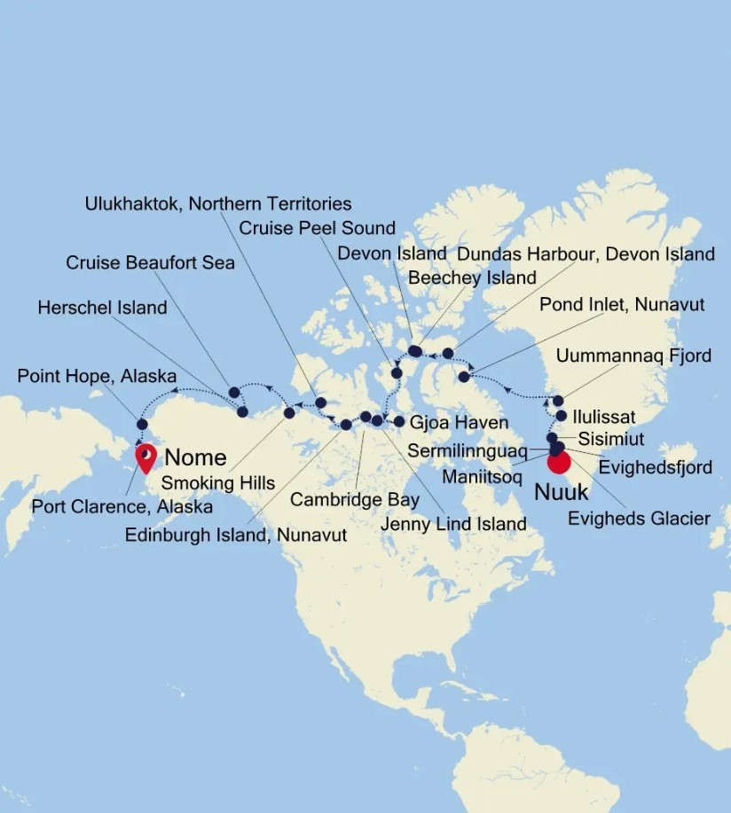
• Greenland's Natural Beauty: Your journey continues in Greenland, where you'll explore the picturesque Sermilinnguaq and Maniitsoq. These locations offer breathtaking landscapes and unique opportunities to immerse yourself in the beauty of Greenland.
• Glacial Encounters: Your voyage takes you to Sisimiut and Ilulissat, known for their impressive glaciers. With two excursions planned in Ilulissat, you'll have the chance to witness the grandeur of these ice formations up close.
• Arctic Exploration: As you cross into Canadian waters, you'll visit historic sites like Beechey Island and Edinburgh Island, where famous Arctic expeditions took place. This part of your journey offers insights into the history of Arctic exploration.
|
Book now |
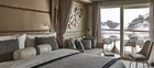
Classic Veranda Suite

Superior Veranda Suite
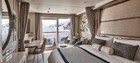
Deluxe Veranda Suite

Premium Veranda Suite
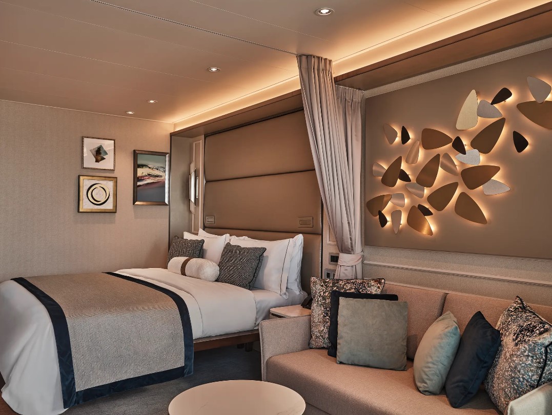
Silver Suite

Owner's Suite
Grand Suite
Vessel Type: Luxury Expedition
Length: 164.40 metres
Passenger Capacity: 200
Built: 2021
Designed for polar exploration, Silver Endeavour breaks the ice of luxury expedition travel.
We’re proud to announce that our newest addition has joined the fleet. Built to PC6 Polar Class specifications – one of the highest Polar Class classifications there is – Silver Endeavour revolutionises our expedition voyages, and allows us to travel deeper to some of the planet’s farthest flung coasts. Her statistics speak for themselves: from unrivalled, industry-leading crew-to-guest, zodiac-to-guest and expert-to-guest ratios, to cutting-edge navigation and exploration technology and hallmark Silversea comfort make her the most luxurious expedition ship ever built.
Spread over eight public decks, not only does she feature ample onboard space, multiple restaurants, plus a huge choice of bars and lounges, but her large and luxurious suites are some of the best in expedition cruising. Superbly designed, all her suites feature a balcony and our highest standards of service thanks to an impressive crew-to-guest ratio of 1:1.
Mud Room
Silver Endeavour’s Mud Room is the perfect place to prepare for all your expedition activities. Spaciously designed, the two mud rooms are superbly modern, and equipped with state-of-the-art equipment.
Explorer Lounge
Strategically located mid-ship on deck 4, the Explorer Lounge is the operational heart of shore excursions while onboard. This is where you’ll attend your daily recap and briefing sessions or attend lectures.
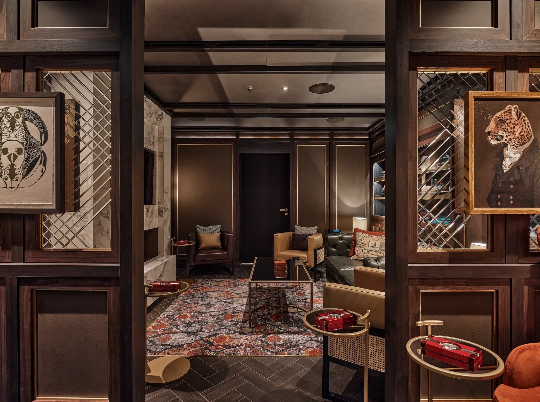
Connoisseur’s Corner
The Connoisseur’s Corner is an indulgent and sophisticated cigar lounge, where you can enjoy an after dinner drink in a cosy private club atmosphere.
Otium Spa
Otium is where you can relax and unwind, but also where you can enjoy world class treatments that make sure you look as good as you feel and that even Venus herself would envy.
Observation Lounge
The Observation Lounge offers one of our favourite vantage points of Silver Endeavour. Plus 270-degree surrounding glass windows make this immersive venue ideal whatever time of the day.
Beauty Salon
Our committed and competent team of beauty therapists is here to help keep your hair, nails, skin, and body healthy and happy.
Fitness Centre
Whether you are a serious keep fit fanatic or casual athlete, you’ll find what you’re looking for in Silver Endeavour’s Fitness Centre. Expertly designed classes and personal training sessions make sure that you keep in shape.
Boutique
Located mid-ship on Deck 5, the Boutique aboard Silver Endeavour means luxury shopping experiences do not end just because you’re at sea! Carefully selected partners offer a wide selection of the latest fashions.
Pool Deck
Surrounded by glazing extended all the way to the top of the venue, the Pool Deck gives you the feeling of always being connected to the sea. The glass-enclosed pool deck is the ideal place to enjoy breathtaking views.
Library
Whether you’re an avid bibliophile or simply prefer a quiet place while at sea, it’s hard not to fall in love with Silver Endeavour’s onboard library, with its beautiful reference books, comfortable chairs and stunning scenery.


Optional tours and excursions available. Please contact us for more details.
Inclusions
• Voyage on board in selected cabin category
• Butler service in every suite
• All meals on board*
• Beverages on board (Select wines, spirits and non-alcoholic beverages)
• Crew Gratuities (Excluding Spa & salon staff)
• Expedition excursions
• Lectures and entertainment on board
• Free wif-fi (Subject to coverage)
• Laundry service included for certain fare categories
• Self service laundry facilities available
• In country flights where required by the itinerary
*Some onboard restaurants incur an additional cost
• PRIVATE EXECUTIVE TRANSFERS
• INTERNATIONAL FLIGHTS - ECONOMY CLASS or Business Class upgrade at reduced rates
• AIRPORT TRANSFERS
• HOTEL
Exclusions
• International flights unless otherwise stated
• Passport and visa costs if applicable
• Travel insurance
• Optional shore excursions
• Spa and Salon Treatments
• Complete valet services, including laundry, pressing and dry cleaning, are available at an additional charge

Our Associates Include
