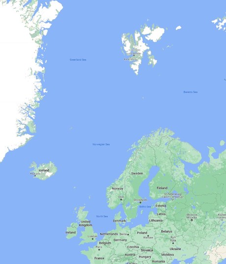
Circle the land of fire and ice - where waterfalls roar, volcanoes slumber, and glaciers crawl. Discover lore and legend on the windswept Faroe Islands and Scottish Isles before bearing north for breathtaking encounters with frozen Svalbard. Take to Zodiacs seeking endemic wildlife from galloping reindeer, and whales rolling through the frigid waters of this icy realm. Tromsø's snow-capped peaks and natural light shows cap a most extraordinary adventure.


Highlights


• Explore the charming town of Akureyri in Iceland, where you can choose from seven exciting excursions to discover the region's natural beauty, cultural heritage, and unique experiences.

• Experience the stunning landscapes and wildlife of the Faroe Islands during your visit to Tórshavn and Klaksvik, with a total of eight diverse excursions to choose from.

• Discover the rich history and captivating beauty of the Shetland Islands, as you explore Lerwick and Noss, offering five engaging excursions that showcase the islands' heritage and natural wonders.

• Embark on a memorable journey to Svalbard, Norway, where you can explore the northern and southern regions with a total of nine exciting excursions, including a cruise to Bear Island and the chance to discover the unique wildlife and landscapes of the Arctic.

The capital of Iceland’s land of ice, fire and natural wonder, Reykjavik is a city like no other - blossoming among some of the world’s most vibrant and violent scenery. Home to two-thirds of Iceland’s population, Reykjavik is the island’s only real city, and a welcoming and walkable place - full of bicycles gliding along boulevards or battling the wind when it rears up. Fresh licks of paint brighten the streets, and an artistic and creative atmosphere embraces studios and galleries - as well as the kitchens where an exciting culinary scene is burgeoning. Plot your adventures in the city's hip bars and cosy cafes, or waste no time in venturing out to Iceland’s outdoor adventures. Reykjavik’s buildings stand together - below the whip of winter’s winds - together with the magnificent Hallgrímskirkja church, with its bell tower rising resolutely over the city. Iceland’s largest church's design echoes the lava flows that have shaped this remote land and boasts a clean and elegant interior. The Harpa Concert Hall’s sheer glass facade helps it to assimilate into the landscape, mirroring back the city and harbour. Its LED lights shimmer in honour of Iceland’s greatest illuminated performance – the northern lights. Walk in the crusts between continents, feel the spray from bursts of geysers and witness the enduring power of Iceland’s massive waterfalls. Whether you want to sizzle away in the earth-heated geothermal pools, or hike to your heart’s content, you can do it all from Reykjavik - the colourful capital of this astonishing outdoor country.
Stykkishólmur, located in western Iceland at the northern end of the Snæfellsnes peninsula, is the commerce center for the area. Its natural harbor allowed this town to become an important trading center early in Iceland’s history. The first trading post was established in the 1550s, and still today fishing is the major industry. The town center boasts beautiful and well-preserved old houses from earlier times. Stykkisholmur is very environmentally conscious – it was the first community in Europe to get the EarthCheck environmental certification, was the first municipality in Iceland to start fully sorting its waste, and was the first town in Iceland to receive the prestigious Blue flag eco-label for its harbor. It has also been a European Destination of Excellence (EDEN), since 2011. Flatey is the ‘flat island’ just as the name sounds. These days Flatey is mainly seasonally populated with many brightly painted, wooden summer cottages to be found here. Like many other small islands around Iceland though, Flatey was once a hub for fishing and trade. This particular island prospered so much that it was the center of commercial and cultural life in the 19th century for this part of Iceland. Thanks to the surroundiung nutrient-rich waters 35 species of birds have been counted on Flatey ranging from Eider Ducks and Atlantic Puffins, to Arctic Terns, Red-necked Phalaropes, Ringed Plover and Snow Buntings.
Vigur Island is the second largest island in the Isafjardardjup Fjord, measuring 2 kilometers in length by 400 meters in width. It is home to a single sheep farming family, which ferries the sheep in summer across to the mainland, so that the Eider Ducks nesting on the island will not be disturbed. One of the export articles from this small island was eider down and one can still see where the Eider Ducks nest and how the down is collected and cleaned. The small settlement of a few houses is on the southern side, next to a small rocky beach, a concrete wall and floating pier. On approach grey seals can often be seen on the otherwise seaweed-covered boulders. Apart from the grey of the basalt and green of the grass, lichens add a splash of color. A path has been prepared and the grass cut, so that visitors can leisurely walk across the island to take in the beautiful scenery and to observe the large colony of Arctic Terns, Black Guillemots and Atlantic Puffins usually only seen during the summer months. A meticulously preserved historical landmark, a small windmill dating back to the 1840s was still in use in 1917 to grind wheat imported from Denmark. Viktoria House, one of the preserved wooden farm houses dating back to 1862, is used as a café where home-baked cakes and cookies are offered to guests. One of Europe’s smallest post offices can be found here, too. Although the Hornstrandir Nature Reserve is further north across the Isarfjardardjup, Bolungarvik is Westfjords’ and Iceland’s northernmost town. Despite its relative isolation, Bolungarvik has been settled for hundreds of years and is already mentioned in the settlement period of Iceland. Located next to rich fishing grounds and the cove of the same name, Bolungarvik has always been a place for fishermen and one of the town’s attractions is a replica of an old fishing station. Just to the northwest is Bolafjall Mountain which blocks off the wind and swell from the Atlantic Ocean. The view from the top (at 638 meters above sea level) not only covers Bolungarvik and the surrounding valleys and mountains, but several fjords and the Hornstrandir Nature Reserve. Although only 950 residents call Bolungarvik their home, this is the Westfjords’ second largest town. There even is a nine hole golf course (par 71) with 18 sets of tees.
Iceland’s Capital of the North is the gateway to a thrilling land of roaring waterfalls, soaring volcanoes and glorious wildlife. It may lie a mere 60 miles from the Arctic Circle, but Akureyi blossoms with a bright, cosmopolitan feel, and explodes into life during the summer months, when its outdoor cafes and open-air bathing spots fill up with visitors ready to immerse themselves in Iceland’s cinematic scenery. Feel the thundering impact of Iceland’s celebrated natural wonders shaking your bones at Godafoss Waterfalls, known as the ‘Waterfalls of the Gods’. Here, the Skjálfandafljót river unleashes a colossal torrent of water over charcoal-black rocks below. Or, find some peace at the Botanical Gardens, which opened in 1957 and offer space for contemplation - amid plants that bloom with unexpected vibrancy, even at this northerly latitude. The Lutheran, Akureyrarkirkja Church rises like a grand church organ and is the town’s most striking landmark. The 112-step climb is worth the effort to see light flooding in through its narrow stain glass windows, spreading colourful patchworks across the interior. Magic and mythology are important elements of Icelandic folklore, and you’ll even bump into giant sculptures of grizzled, child-snatching trolls on the town’s high street. Or, meet more earthly - but no less magical - creatures in the waters around Akureyi, where immense blue whales cruise by and dolphins playfully leap.
A world of tumbling waterfalls and colourful creativity, Seydisfjordur is Iceland at its most epic and eccentric. A spectacular fjord lends the town its name, and the structures are dwarfed by this majestic setting, as they huddle around its glassy waters. Sail around the fjord, head out on a kayak amid the scenery, or venture to meet Puffins and other nesting birds settled on sharp cliffs. Encounter sea lions, or try some fishing as you immerse yourself in this highlight of the wild and wonderful Eastfjords. Herring fishing sustained this settlement founded by Norwegians in 1848, leading to a town of colourful wooden buildings, which gleam white against the moody scenery's palette, providing a spirit-lifting splash of colour during the harsh winter months. A rainbow pathway leads to a pretty, pastel-blue church and there's more local art and culture to unravel at Skaftfell, which displays bright and bold contemporary art. Its bistro also serves up a perfect caffeine hit and refreshments. Waiting on the open jaws of the Seydisfjordur, this is a gloriously picturesque town, and the steep fjord banks reflect beautifully on the smooth waters below. The snow-capped Bjólfur mountain stands above the town and invites you to crunch along hiking trails amid untouched nature - rewarding with mesmerising views across the fjord and town below. These hills can literally sing thanks to a unique sculpture - which resonates with a traditional five-tone harmony. The remote and gorgeous Skalanes Nature reserve is a major draw, with 47 bird species resting on its dramatic bird cliff, along with countless plant varieties.
Slow the pace and discover the refreshing approach to life that Djupivogur has made its trademark. You can leave your phone behind as you step out into this Icelandic town, which has won awards celebrating its leisurely outlook and stubborn rebellion against the frenetic pace of modern life. After all, who needs emails and notifications when you have some of the most humbling monochrome scenery and gashed fjords, waiting on your doorstep? Sitting on a peninsula to the south-east of Iceland, the glacial approach to life here wins many hearts. A place where hammers knock on metal in workshops, artists ladle paint onto canvases, and where you might spot a few Icelandic horses roaming across mountains, Djupivogur is an uninhibited artistic hub - full of makers and creatives. The most expansive project is the 34 egg sculptures that dot the coastline, created by the Icelandic artist, Sigurður Guðmundsson. Each egg represents a different native bird species. Fishing remains the primary industry, and you can savour the soft fruits of the labour in restaurants serving up smoked trout and fish soup within their cosy confines. Wander the surrounding landscapes, where snow-freckled mountains rise, and lazy seals lie on dark rock beaches, to feel Djupivogur's natural inspiration seeping under your skin. Alive with greens and golds in summer, further ventures reveal glaciers and the sprawling waterfalls of Vatnajökull National Park. The cliff-hugging puffins of Papey Island are a must see, while Bulandstindur Mountain's pyramid shape is a stand out even among these fairy-tale landscapes.
Titanic scenery, mist-whipped mountains and staggering oceanic vistas await you here in the Faroe Islands - a far-flung archipelago of immense natural beauty. This remote and isolated gathering of 18 islands – adrift in the far North Atlantic Ocean – is a self-governing part of the Kingdom of Denmark, and colourful Tórshavn bustles up against the seafront, forming one of the tiniest capital cities in the world. Wander between pretty, half-timbered houses and visit one of the world’s oldest parliament buildings, during your time here. With Viking history swirling too, Torshavn is a quaint, charming and heritage-rich city. Surrounded by thrilling landscapes, and cosy Scandi culture, the Faroe Islands are an envy-inducing, off-the-beaten-track destination. From Torshavn, scatter to your choice of island destinations, or spend time soaking in the storybook appeal and clarity of air in the scenic old town. Pop into local shops or head for restaurants - where you can taste local foods like salt-cured fish and hunks of lamb. See waterfalls plummeting directly into the ocean from vertical cliffs, along with emerald-green carpeted fjords, as you explore these extraordinary, lost islands. Puffins and sea birds relish the island’s craggy sea cliffs and coastline – visit the island of Mykines to see the birds burrowing deep into the steep cliffs to nest. Strap on your hiking boots to rise to the challenge of the mesmerising scenery. Fjords etch into the coastline, and you can encounter peaceful lakes and massive valleys dug out by glaciers. Off-shore, sea stacks totter up out of the swelling, frothy waves.
Featuring rich hiking dramatic boat journeys and fascinating heritage Klaksvik opens up the Northern Isles' slender fingers of scenic land for your exploration. Klaksvik is the second largest of the Faroe Islands' towns and this scenic fishing capital is set amongst a dramatic valley overlooking the conical protrusion of Kunoy island – the Faroe's highest peak. This is a town full of stories. Viking-era history and breathtaking natural scenery entice visitors to Klaksvik making it the perfect base for further explorations of these wild and remote fantasy islands. Pretty Christianskirkjan church was constructed from local materials and rises as a modern elegant church inspired by old Norse architecture. Dating back to 1963 it's elegantly lit and full of detail. Look up to see the suspended wooden boat which survives from 1890 and was used by the sea-faring local priest to visit the surrounding communities. The boat is now dedicated to those lost at sea having survived a storm in 1913. The granite font alone has 4 000 years' worth of history. These islands may be remote but they are teeming with birdlife. Sail out to the sheer cliff faces where adorable puffins and kittiwakes breed. Gorgeous hikes will take you across scenic mountain passes through historic hamlets and high up above stunning viewpoints like the one waiting at Hálsur. Or climb on a bike to feel the wind in your hair as you explore at your own pace along paths roaming through fertile green valleys.
Adrift between the Scottish and Norwegian coasts, the craggy Shetland Islands form the most northerly point of the British Isles. Sprawling across 100 islands, connected by sandy bridges and crisscrossing ferries, explore the highlights of this scenic archipelago outpost. With incredible Neolithic history, spanning 5,000 years of human heritage, these islands, which sit just shy of the Arctic Circle, are an isolated and immense treasure trove of history and thrilling scenery. Look out over dramatic coastline from atmospheric Iron Age towers. Sweeping, windswept beaches and wisps of sand connect islands and rugged cliffs - stand back as the sounds of the waves smashing against the shore and calling gulls fills the air. The islands are also home to some of the most adorable four-legged creatures you’ll ever meet, the diminutive and wavy-fringed, Shetland Ponies who roam the hills and reach a maximum size of 42 inches. Don't be fooled, though, they are amongst the strongest and toughest of all breeds. Their existence here points to Viking history, as local horses bred with ponies brought ashore by Norse settlers, creating the lovable crossbreed that is an icon of these islands today. The towering Broch of Mousa is perhaps Europe’s best-preserved Iron Age building - and one of the Shetland's finest brochs - a series of round, stone towers, believed to have been constructed around 100 BC. Seals and birdlife ensure that the isolated islands are always well-populated with life - and you can embark on hikes to discover their coastal homes. Lerwick is the islands’ capital, and there's a charming welcome on offer, as you arrive before the waterfront of stone buildings, which cascade down to the shore. Exploring the sandstone cliff faces of the Isle of Noss will reveal ledges loaded with gannets, puffins, guillemots, shags, kittiwakes, Razorbills, fulmars and Great Skuas. The island was recognized as a National Nature Reserve in 1955, and has one of Europe’s largest and most diverse seabird colonies. Sheep have grazed the inland hillsides of Noss since the late 1800s and early 1900s when around twenty people lived on the island to manage the sheep farm. Along with the sheep, shaggy Shetland ponies graze the windblown slopes of Noss.
Modern Stromness hasn’t changed dramatically since the turn of the last century and stone houses still stand over cobbled streets, but Orkney’s main historic claim is the rich legacy of Neolithic sites and artefacts found here. It was proclaimed a UNESCO World Heritage Site in 1999 under the title “Heart of Neolithic Orkney.” The most famous of these monuments is probably the settlement of Skara Brae, once a small village of 50-100 people living together near the shores of Skaill Bay. Occupied from roughly 3180 BCE-2500 BCE, the site has given us invaluable insight into the daily lives of our forebears, and Skara Brae forms the hub of a network of Neolithic sites across the Orkneys, many of which are still being excavated. Other sites include the standing stones of the Ring of Brodgar, situated on an isthmus between the sea loch of Stenness and the freshwater loch of Harray.
Skye epitomizes Scotland's wild celtic appeal. A turbulent geological history has given this beautiful, rugged island some of Britain's most varied and dramatic scenery. Steeped in mystery, romance and adventure, the Isle of Skye is perhaps the most well-known of Scotland's many islands. Charles Edward Stuart, better known as Bonnie Prince Charlie, escaped here from the mainland disguised as a maidservant of a woman by the name of Flora MacDonald. The north of the island is dominated by a rugged volcanic plateau, the south by the Cuillins mountain range, whose peaks were sculpted by the glaciers of the Ice Age. Skye is divided by numerous sea lochs allowing continuous proximity to the sea. The limestone grasslands of the south are the home of sheep and cattle. Scattered about are ruins of crofts, small holdings used for grazing; they were abandoned as their owners fell into poverty due to lack of income. Dunvegan is situated in a sheltered sea loch, or fjord, on the northwestern coast of the island on the Waternish peninsula. The small settlement is dominated by Dunvegan Castle. The oldest inhabited castle in Scotland, it has been the seat of the chiefs of the Clan MacLeod for the past 700 years. It offers insights into Scotland's clan spirit with paintings and relics from the MacLeod Clan. The gardens were originally laid out in the 18th century and are of considerable interest with the woodland glades, shimmering pools and a multitude of rhododendrons. Loch Dunvegan is home to a seal colony; the two main varieties are the brown seal and the great gray Atlantic seal. Small local boats depart from the jetty at frequent intervals throughout the day enabling close observation of these playful sea mammals.
Gloriously remote, St. Kilda is an archipelago 50 miles off the Isle of Harris. Although the four islands are uninhabited by humans, thousands of seas birds call these craggy cliffs home, clinging to the sheer faces as if by magic. Not only is St. Kilda home to the UK’s largest colony of Atlantic Puffin (almost 1 million), but also the world largest colony Gannets nests on Boreray island and its sea stacks. The islands also home decedents of the world’s original Soay sheep as well as having a breed of eponymously named mice. The extremely rare St. Kilda wren unsurprisingly hails from St. Kilda, so birders should visit with notebook, binoculars and camera to hand. While endemic animal species is rife on the island, St. Kilda has not been peopled since 1930 after the last inhabitants voted that human life was unsustainable. However, permanent habitation had been possible in the Medieval Ages, and a vast National Trust for Scotland project to restore the dwellings is currently being undertaken. The islands even enjoyed a status as being an ideal holiday destination in the 19th century. Today, the only humans living on the islands are passionate history, science and conservation scholars. One of the caretakers even acts as shopkeeper and postmaster for any visitors who might like to send a postcard home from St. Kilda. It should be noted that St. Kilda is the UKs only (and just one of 39 in the world) dual World Heritage status from UNESCO in recognition of its Natural Heritage and cultural significance. As an isolated island of the remote St Kilda Group, Boreray island is one of the most far flung and weather impacted islands of the North East Atlantic. Imagine trying to live here during stormy weather. Landing requires jumping or swimming ashore; and yet the island has been lived on or visited from Neolithic times. Collecting seabirds and their eggs, and storing them for winter, may have been even more important than raising sheep. Boreray Sheep are the rarest breed of sheep in Britain. They evolved from short-tailed sheep brought from the Scottish mainland but have been isolated long enough to have evolved into a distinctive small and horned breed. Only found on Boreray Island, they remained as a wild flock when the last people left the St Kilda Islands in 1930. The Souy are a separate and different breed of sheep found on the other St Kilda Islands. Look out for the Boreray Sheep grazing on the slopes of hilly Boreray Island. Seabirds thrive on Boreray and its two attendant rocks stacks, raising new chicks each summer. Northern Gannets glide overhead as they attempt difficult landings at nest sites. Seeing gannets plunge from a great height into the sea is an exciting way to understand the effort required to feed themselves and chicks. Northern Fulmers nest on the volcanic rock cliffs and Atlantic Puffins fly in and out of burrow-strewn slopes. Boreray is part of the St Kilda World Heritage Site, a rare example of a site recognised for both its outstanding natural and cultural values.
Days at sea are the perfect opportunity to relax, unwind and catch up with what you’ve been meaning to do. So whether that is going to the gym, visiting the spa, whale watching, catching up on your reading or simply topping up your tan, these blue sea days are the perfect balance to busy days spent exploring shore side.
The name Vestmannaeyjar refers to both a town and an archipelago off the south coast of Iceland. The largest Vestmannaeyjar island is called Heimaey. It is the only inhabited island in the group and is home to over 4000 people. The eruption of the Eldfell Volcano put Vestmannaeyjar into the international lime light in 1973. The volcano’s eruption destroyed many buildings and forced an evacuation of the residents to mainland Iceland. The lava flow was stopped in its tracks by the application of billions of liters of cold sea water. Since the eruption, life on the small island outpost has returned to the natural ebb and flow of a small coastal fishing community on the edge of the chilly and wild North Atlantic. On 14 November 1963, a trawler passing the southernmost point of Iceland spotted a column of smoke rising from the sea. Expecting to find a burning boat they were surprised to find instead, explosive volcanic eruptions. They were witnessing the birth of a new island. Columns of ash reached heights of almost 30,000 feet in the sky and could be seen on clear days as far away as Reykjavík. The eruptions continued for three and a half years, ending in June 1967. Once formed, Surtsey was 492 feet above sea level and covered an area of almost 2 square miles. The island was named after the Norse fire god Surtur. It is a perfect scientific study area used to understand the colonization process of new land by plant and animal life.
The capital of Iceland’s land of ice, fire and natural wonder, Reykjavik is a city like no other - blossoming among some of the world’s most vibrant and violent scenery. Home to two-thirds of Iceland’s population, Reykjavik is the island’s only real city, and a welcoming and walkable place - full of bicycles gliding along boulevards or battling the wind when it rears up. Fresh licks of paint brighten the streets, and an artistic and creative atmosphere embraces studios and galleries - as well as the kitchens where an exciting culinary scene is burgeoning. Plot your adventures in the city's hip bars and cosy cafes, or waste no time in venturing out to Iceland’s outdoor adventures. Reykjavik’s buildings stand together - below the whip of winter’s winds - together with the magnificent Hallgrímskirkja church, with its bell tower rising resolutely over the city. Iceland’s largest church's design echoes the lava flows that have shaped this remote land and boasts a clean and elegant interior. The Harpa Concert Hall’s sheer glass facade helps it to assimilate into the landscape, mirroring back the city and harbour. Its LED lights shimmer in honour of Iceland’s greatest illuminated performance – the northern lights. Walk in the crusts between continents, feel the spray from bursts of geysers and witness the enduring power of Iceland’s massive waterfalls. Whether you want to sizzle away in the earth-heated geothermal pools, or hike to your heart’s content, you can do it all from Reykjavik - the colourful capital of this astonishing outdoor country.
Stykkishólmur, located in western Iceland at the northern end of the Snæfellsnes peninsula, is the commerce center for the area. Its natural harbor allowed this town to become an important trading center early in Iceland’s history. The first trading post was established in the 1550s, and still today fishing is the major industry. The town center boasts beautiful and well-preserved old houses from earlier times. Stykkisholmur is very environmentally conscious – it was the first community in Europe to get the EarthCheck environmental certification, was the first municipality in Iceland to start fully sorting its waste, and was the first town in Iceland to receive the prestigious Blue flag eco-label for its harbor. It has also been a European Destination of Excellence (EDEN), since 2011. Flatey is the ‘flat island’ just as the name sounds. These days Flatey is mainly seasonally populated with many brightly painted, wooden summer cottages to be found here. Like many other small islands around Iceland though, Flatey was once a hub for fishing and trade. This particular island prospered so much that it was the center of commercial and cultural life in the 19th century for this part of Iceland. Thanks to the surroundiung nutrient-rich waters 35 species of birds have been counted on Flatey ranging from Eider Ducks and Atlantic Puffins, to Arctic Terns, Red-necked Phalaropes, Ringed Plover and Snow Buntings.
Vigur Island is the second largest island in the Isafjardardjup Fjord, measuring 2 kilometers in length by 400 meters in width. It is home to a single sheep farming family, which ferries the sheep in summer across to the mainland, so that the Eider Ducks nesting on the island will not be disturbed. One of the export articles from this small island was eider down and one can still see where the Eider Ducks nest and how the down is collected and cleaned. The small settlement of a few houses is on the southern side, next to a small rocky beach, a concrete wall and floating pier. On approach grey seals can often be seen on the otherwise seaweed-covered boulders. Apart from the grey of the basalt and green of the grass, lichens add a splash of color. A path has been prepared and the grass cut, so that visitors can leisurely walk across the island to take in the beautiful scenery and to observe the large colony of Arctic Terns, Black Guillemots and Atlantic Puffins usually only seen during the summer months. A meticulously preserved historical landmark, a small windmill dating back to the 1840s was still in use in 1917 to grind wheat imported from Denmark. Viktoria House, one of the preserved wooden farm houses dating back to 1862, is used as a café where home-baked cakes and cookies are offered to guests. One of Europe’s smallest post offices can be found here, too. Although the Hornstrandir Nature Reserve is further north across the Isarfjardardjup, Bolungarvik is Westfjords’ and Iceland’s northernmost town. Despite its relative isolation, Bolungarvik has been settled for hundreds of years and is already mentioned in the settlement period of Iceland. Located next to rich fishing grounds and the cove of the same name, Bolungarvik has always been a place for fishermen and one of the town’s attractions is a replica of an old fishing station. Just to the northwest is Bolafjall Mountain which blocks off the wind and swell from the Atlantic Ocean. The view from the top (at 638 meters above sea level) not only covers Bolungarvik and the surrounding valleys and mountains, but several fjords and the Hornstrandir Nature Reserve. Although only 950 residents call Bolungarvik their home, this is the Westfjords’ second largest town. There even is a nine hole golf course (par 71) with 18 sets of tees.
Iceland’s Capital of the North is the gateway to a thrilling land of roaring waterfalls, soaring volcanoes and glorious wildlife. It may lie a mere 60 miles from the Arctic Circle, but Akureyi blossoms with a bright, cosmopolitan feel, and explodes into life during the summer months, when its outdoor cafes and open-air bathing spots fill up with visitors ready to immerse themselves in Iceland’s cinematic scenery. Feel the thundering impact of Iceland’s celebrated natural wonders shaking your bones at Godafoss Waterfalls, known as the ‘Waterfalls of the Gods’. Here, the Skjálfandafljót river unleashes a colossal torrent of water over charcoal-black rocks below. Or, find some peace at the Botanical Gardens, which opened in 1957 and offer space for contemplation - amid plants that bloom with unexpected vibrancy, even at this northerly latitude. The Lutheran, Akureyrarkirkja Church rises like a grand church organ and is the town’s most striking landmark. The 112-step climb is worth the effort to see light flooding in through its narrow stain glass windows, spreading colourful patchworks across the interior. Magic and mythology are important elements of Icelandic folklore, and you’ll even bump into giant sculptures of grizzled, child-snatching trolls on the town’s high street. Or, meet more earthly - but no less magical - creatures in the waters around Akureyi, where immense blue whales cruise by and dolphins playfully leap.
Days at sea are the perfect opportunity to relax, unwind and catch up with what you’ve been meaning to do. So whether that is going to the gym, visiting the spa, whale watching, catching up on your reading or simply topping up your tan, these blue sea days are the perfect balance to busy days spent exploring shore side.
Humpback and minke whales cavort and feed in the waters around the impressive volcanic island of Jan Mayen with its towering ebony peaks and broad black lava beaches. The primordial landscape is dominated to the north by the 7,500 feet high (2,300 meters) Mt Beerenberg, an active volcano covered in glacial ice that last erupted in 1985. With permission from the Norwegian authorities, a landing is possible at this rarely visited outpost. Visitors may walk to the research and weather station, or beyond, for birds-eye views of the meteorological station and the long black sandy eastern shore of the island. Birds to be seen here may include Atlantic Puffins, Northern Fulmars, and Snow Buntings.
Days at sea are the perfect opportunity to relax, unwind and catch up with what you’ve been meaning to do. So whether that is going to the gym, visiting the spa, whale watching, catching up on your reading or simply topping up your tan, these blue sea days are the perfect balance to busy days spent exploring shore side.
Svalbard’s northern region is less influenced by the Norwegian Current coming through the Greenland Sea than the southern region and shows more ice. The northern part of the island of Spitsbergen shows quite a number of impressive fjords, bays and glaciers. The Nordaust Svalbard Nature Reserve includes Spitsbergen’s east coast, the Hinlopen Strait, Nordaustlandet and some islands further east like Kvitoya and Storoya. Several walrus haul-outs, spectacular glaciers, bird cliffs and bird islands, as well as surprising flora in Arctic deserts and the possibility to see polar bears and to visit historically important sites make this an area prone for exploration. Ice conditions will dictate which sites can be seen.
Svalbard’s Southern Region and specifically Spitsbergen’s west coast is less ice-clogged than the rest of Svalbard due to the moderating influenced of the Gulf Stream. Several fjords cut into the western coast of Spitsbergen and have been used by trappers and hunters, as well as the different mining companies that tried to exploit the riches of the archipelago’s largest island of Spitsbergen. Remains of huts and mines, as well as active commercial and scientific settlements can be found and visited. Depending on the time of the season, glaciers can be visited on foot or by sea. Hornsund will reveal fascinating views of geological formations, craggy mountains, spectacular glaciers and a variety of seabirds and seals.
Bear Island is considered Svalbard’s southernmost island, roughly half way between Spitsbergen and Norway’s North Cape. Although the last polar bears were seen in 2004, the name goes back to Dutch explorer Willem Barentsz and his visit in 1596. The island has been used to hunt walrus, for whaling, and even coal mining has taken place. The strategic location on the border of the Norwegian Sea and the Barents Sea has led to a meteorological station being set up by Norway near Gravodden on Bear Island’s north coast. Some two thirds of the island is a relatively flat plain with shallow freshwater lakes and Ramsar Wetland, while the entire island and the surrounding waters are a Nature Reserve. Bear Island has also been designated an Import Bird Area as it is a staging area for Pink-footed and Barnacle Geese and the steep cliffs south of Sørhamna are home to thousands of breeding seabirds. This is a specially protected area where Zodiacs are allowed to cruise along the cliffs around Kapp Kolthoff. In smaller amounts Atlantic Puffins, Northern Gannets, Glaucous Gulls and Great Skuas are found in between the large Black-legged Kittiwake, Little Auk, Common Guillemot and Brünnich’s Guillemot colonies. The constant battering of the sea has not only created impressive sea caves and tunnels, but unfortunately the Russian vessel Petrozavodsk shipwrecked near Revdalen at the base of the limestone cliffs and the waves are causing a continuous disintegration of the remains of the ship.
Home more than a million birds that perch atop its cliffs, the Gjesværstappan islands are a marvel of nature. Gjesværstappan is a grouping of nearly one hundred islands and rocks, mostly high, steep-sided islands covered in grass that is nearly covered by seabirds. These islands were designated as a nature reserve in 1983 due to their importance as nesting grounds for many species of seabirds, some of them endangered. A birdwatcher’s paradise, Gjesværstappan is noted as one of the more easily-accessed nesting areas inEurope for viewing Atlantic seabirds. It is comprised of several particularly large, tall islands, including Storstappan (rising 283 meters, or 928 feet, out of the sea), Kjerkestappen (166 meters or 545 feet) and Bukkstappen (92 meters, 302 feet). On Storstappan alone, more than one million nesting birds have been counted, and visitors are not allowed to set foot here between June and August to protect its activity as a nesting and breeding ground. The islands of Gjesværstappan are home to one of the most important colonies of Atlantic Puffins in Norway. Other birds that visitors may see include White-tailed Eagles, Arctic Skuas, Common Eider Ducks, Razorbills, Guillemots (black and common), Great Cormorants, Gannets and other species. Tour the islands from a small water craft (kayak or Zodiac) and prepare to be amazed at the splendor of the dramatic cliffs rising from the sea, vibrant and positively teeming with birdlife. Situated at the very north tip of Norway and inside the Arctic Circle, there is something very special about being (almost) at the top of the world. Called the northernmost point of Europe, the North Cape (Nordkapp in Norwegian) lies about 1,306.3 mi from the North Pole, with no dry land between except for the Svalbald archipelago. Home to where the Atlantic and Arctic oceans meet, this is the true land of the midnight sun – constant spectacular scenic views and 24-hour sunlight lends itself to a sense of giddy informality aboard. Just imagine sipping a chilled glass of champagne at the very top of the world in full daylight at midnight – sensational. Be sure to be on the lookout for hundreds of thousands of puffins, gannets, cormorants, seals, dolphins and whales that make this stretch of chilly water their home. Not forgetting the colourful, compact fishing villages, so at odds with the otherwise this stark, barren landscape. For those who like to travel far (very far) off the beaten track, then you have found your Nordic nirvana in Skarsvag. Large, sparsely populated (there are just 60 human year round residents), and a joy to all those who revel in stark, unbridled beauty, Skarsvag also enjoys the auspicious title of being the world’s most northerly fishing village. But rolling hills, prolific birdlife and arctic fjords aside, Skarsvag is above all famous for its proximity to the North Cape. Found on the island of Magerøya, the most northernmost point of Europe above the arctic circle is a bucket list basic. Stand beneath the massive metal globe and gaze out onto the Barents Sea, where the only land between you and the North Pole is the Svalbard archipelago. This is truly the land of the midnight sun – in fact, you are so far north that the sun doesn’t even dip beneath the horizon between May and mid-July. The island’s famous bird cliffs are quite spectacular, and home to thousands of puffins, gannets and cormorants. Those willing to hike to cape Knivskjellodden, the northernmost point on Magerøya, will be rewarded with stunning cliff face views of the North Cape Plateau. Before leaving, head into the impressive North Cape Hall for exhibitions on the North Cape’s history. Travellers have been visiting since 1664, when Italian priest Francesco Negri arrived, so there are some tales to tell! More intriguingly, a tunnel has been hewn into the rock, leading down to the cliff face, complete with a chapel.
Feel your heart flutter, as you catch your first glimpse of that famous emerald haze dancing across the stars, during your visit to this wonderful Arctic gateway. Located in the far north of Norway, a visit to Tromso beckons you to the extremes of this magical country, to explore a fairytale land of jagged mountains, glistening glaciers and husky-pulled sledges. Despite its remote location, you'll discover a perhaps surprisingly cosmopolitan city, with a healthy student population injecting plenty of energy. Sat 250 miles above the Arctic Circle - at 69° north - you can bathe in the midnight sun's glow during summer, before winter brings the thick blackness and starry skies of endless polar nights. The darkness doesn't stop the fun - with a polar night half-marathon taking place in January - but the return of the sun is always a reason for a celebration here. To get the best view over the city, take the cable car to Storsteinen's amazing viewpoint. Magnificent views down over the city, fjord and Tromso's arching bridge will unravel before you. Learn more about northerly traditions, polar expeditions and arctic hunting at the Polar Museum. The Science Centre, meanwhile, explains how humans have harnessed and survived these epic landscapes over the years, and explores Tromso's breathtaking natural spectacle - the northern lights. The city is famed for its extraordinary viewing opportunities, which are often said to be the best in the world. The Alpine Botanic Garden is the most northern such garden on the planet, showcasing some of Norway's hardiest plantlife, which survives and thrives at this nose-bleeding altitude.
Itineraries are subject to change.

Classic Veranda Suite

$38,700 AUD pp
Classic Veranda Suite
Located lower bow, the Classic Veranda Suite offers all the comfort and attention to detail that you can expect aboard — both inside and out. A generous expanse of interior comforts — elegant décor, stunning marble bathroom and ample seating area (with sofa bed that is able to accommodate a third berth), offers everything you need for a comfortable cruise. But perhaps this suite’s finest asset lies just outside, as floor-to-ceiling glass doors open onto a private veranda, making every sunset feel as if it is yours alone. One bedroom: 33.1 sq.m. including veranda Wheelchair accessible suite has a bathroom with vanity and shower. Please note that the 3rd guest will sleep on a comfortable sofa bed in the reception area of the suite.

Superior Veranda Suite

$42,900 AUD pp
Superior Veranda Suite
The Superior Veranda Suite is found on the upper decks. From the sumptuous views from the teak veranda to the spacious sitting room (with sofa bed able to accommodate a third berth) and large marble bathroom, everything about the Superior Veranda has been designed for your comfort. A comfortable living space, attention to detail and a generous expanse of amenities makes this stunning suite a cosy home while on the seas. One bedroom: 33.1 sq.m. including veranda Wheelchair accessible suite has a bathroom with vanity and shower. Please note that the 3rd guest will sleep on a comfortable sofa bed in the reception area of the suite.

Deluxe Veranda Suite

$44,900 AUD pp
Deluxe Veranda Suite
Deluxe Veranda Suites keep the iconic suite configuration - one of the most successful in the industry - while enhancing your creature comforts and destination immersion. Located on the privileged upper mid levels, Deluxe Veranda Suites have spacious interiors with a bedroom area that includes a large writing desk and comfortable living room with a convertible sofa (able to accommodate a third berth). Even better, the balcony is larger and more beautiful than ever, offering ample space to relax and enjoy sweeping views, wherever you are. One bedroom: 33.1 sq.m. including veranda Wheelchair accessible suite has a bathroom with vanity and shower. Please note that the 3rd guest will sleep on a comfortable sofa bed in the reception area of the suite.

Premium Veranda Suite

$46,400 AUD pp
Premium Veranda Suite
Our best-selling Premium Veranda Suite is more beautiful and luxurious than ever on board Silver Endeavour. This suite offers a large bedroom space with dreamy bedding, a stunning marbled bathroom with a large vanity and sumptuous walk-in shower. Comfortable furnishings and elegant decor make staying in (almost) as good as going out! Spacious and well-situated, enjoy ultra-luxury amenities from the 24-hour butler service to the well-stocked mini-bar (and yes, they’re all included!). The sofa-bed can easily accommodate a third guest. One bedroom: 33.1 sq.m. including veranda Wheelchair accessible suite has a bathroom with vanity and shower. Please note that the 3rd guest will sleep on a comfortable sofa bed in the reception area of the suite.

Silver Suite

Sold Out
 
Please contact Wild Earth for alternative options or to waitlist.

Grand Suite

Sold Out
 
Please contact Wild Earth for alternative options or to waitlist.

Owner's Suite

Sold Out
 
Please contact Wild Earth for alternative options or to waitlist.

Vessel Type: Luxury Expedition

Length: 164.40 metres

Passenger Capacity: 200

Built: 2021

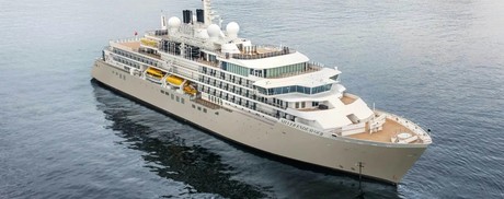
Designed for polar exploration, Silver Endeavour breaks the ice of luxury expedition travel.

We’re proud to announce that our newest addition has joined the fleet. Built to PC6 Polar Class specifications – one of the highest Polar Class classifications there is – Silver Endeavour revolutionises our expedition voyages, and allows us to travel deeper to some of the planet’s farthest flung coasts. Her statistics speak for themselves: from unrivalled, industry-leading crew-to-guest, zodiac-to-guest and expert-to-guest ratios, to cutting-edge navigation and exploration technology and hallmark Silversea comfort make her the most luxurious expedition ship ever built.

Spread over eight public decks, not only does she feature ample onboard space, multiple restaurants, plus a huge choice of bars and lounges, but her large and luxurious suites are some of the best in expedition cruising. Superbly designed, all her suites feature a balcony and our highest standards of service thanks to an impressive crew-to-guest ratio of 1:1.

Mud Room

Silver Endeavour’s Mud Room is the perfect place to prepare for all your expedition activities. Spaciously designed, the two mud rooms are superbly modern, and equipped with state-of-the-art equipment.

Explorer Lounge

Strategically located mid-ship on deck 4, the Explorer Lounge is the operational heart of shore excursions while onboard. This is where you’ll attend your daily recap and briefing sessions or attend lectures.

Connoisseur’s Corner

The Connoisseur’s Corner is an indulgent and sophisticated cigar lounge, where you can enjoy an after dinner drink in a cosy private club atmosphere.

Otium Spa

Otium is where you can relax and unwind, but also where you can enjoy world class treatments that make sure you look as good as you feel and that even Venus herself would envy.

Observation Lounge

The Observation Lounge offers one of our favourite vantage points of Silver Endeavour. Plus 270-degree surrounding glass windows make this immersive venue ideal whatever time of the day.

Beauty Salon

Our committed and competent team of beauty therapists is here to help keep your hair, nails, skin, and body healthy and happy.

Fitness Centre

Whether you are a serious keep fit fanatic or casual athlete, you’ll find what you’re looking for in Silver Endeavour’s Fitness Centre. Expertly designed classes and personal training sessions make sure that you keep in shape.

Boutique

Located mid-ship on Deck 5, the Boutique aboard Silver Endeavour means luxury shopping experiences do not end just because you’re at sea! Carefully selected partners offer a wide selection of the latest fashions.

Pool Deck

Surrounded by glazing extended all the way to the top of the venue, the Pool Deck gives you the feeling of always being connected to the sea. The glass-enclosed pool deck is the ideal place to enjoy breathtaking views.

Library

Whether you’re an avid bibliophile or simply prefer a quiet place while at sea, it’s hard not to fall in love with Silver Endeavour’s onboard library, with its beautiful reference books, comfortable chairs and stunning scenery.

Cabin layout for Silver Endeavour

Optional tours and excursions available. Please contact us for more details.

Inclusions


• Voyage on board in selected cabin category
• Butler service in every suite
• All meals on board*
• Beverages on board (Select wines, spirits and non-alcoholic beverages)
• Crew Gratuities (Excluding Spa & salon staff)
• Expedition excursions
• Lectures and entertainment on board
• Free wif-fi (Subject to coverage)
• Laundry service included for certain fare categories
• Self service laundry facilities available
• In country flights where required by the itinerary

*Some onboard restaurants incur an additional cost
• PRIVATE EXECUTIVE TRANSFERS
• INTERNATIONAL FLIGHTS - ECONOMY CLASS or Business Class upgrade at reduced rates
• AIRPORT TRANSFERS
• HOTEL

Exclusions


• International flights unless otherwise stated
• Passport and visa costs if applicable
• Travel insurance
• Optional shore excursions
• Spa and Salon Treatments
• Complete valet services, including laundry, pressing and dry cleaning, are available at an additional charge
Silver Endeavour
British Isles Luxury ExpeditionLuxury Expedition
31 Days from
$38,700 AUD pp

or call us on

NZ Freephone
0800 945 3327

AUS Freephone
1800 107 715

to help you make your reservation

Get Our Latest Brochure

Featuring the latest small ship cruises to a number of destinations, our Small Ship Cruising brochure is carefully curated to include small ship cruises from expeditions to luxury cruises to the world's most fascinating destinations including Alaska, Croatia, the Galapagos and the Antarctic and Arctic.

Our Associates Include

Adventure Canada
Heritage Expeditions New Zealand
UnCruise Adventures
Hurtugruten
Ponant
Pandaw